Overview. We left our place around 8:40am, returned home around 7:30pm.. Of the places listed in the previous post we reached the first five, although the last one was a bit of a dud. We stuck pretty closely to the
Golden Circle attractions, and mostly had to compete with every other tourist in Iceland for the views and the sights. Apparently, Golden Circle is what everyone does immediately upon arrival - Olga recognized people from our flight and other people she saw at the airport yesterday at different places today... On one hand - not very original. On the other hand: (a) the places we visited are genuinely awesome, and (b) we get to get them out of the way, and leave the rest of the stay (eight more days) for things that are a bit more off the beaten path.
Weather. Quite unexpectedly excellent after Day 1. As we left, the sky was covered in a thick blanket of clouds, but as soon as we turned inland, the sky started clearing. In Thingvellir, the temperature was around 20-21 Celcius, and it kept getting warmer and warmer throughout the day until we hit 30-33 Celcius on the car thermometer at the Geysir/Strokkur location. I am not certain that reading was correct, but that location was hot - at least in part because of all the geothermal activity going on. Later in the day, it cooled off, but stayed in upper teens Celius as we made our way home. Perfect day for this trip.
Thingvallavatn. We had a choice of following our itinerary counter-clockwise, or clockwise. Upon some reflection, I changed the original intent and settled on clockwise direction, starting with
Þhingvellir. As we approached it, our first quick stop was a small viewpoint at the place where the highway approached
Þhingvallavatn, the largest natural lake in Iceland according to Wikipedia. We got to enjoy some really nice views of the morning on the lake with the mist slowly moving along the surface.
 |
Morning @ Thingvallavatn
|
As we were enjoying the views, more and more people kept arriving, foreshadowing the crowds we saw throughout the day.
Thingvellir. The travel websites often do not do justice to Thingvellir, largely obscuring the fact that this is the biggest thing Iceland has for a historic site: the traditional place of meeting of the
Iceland's Allthyngi. The geography is really interesting. The visitor center and the parking are located at the top of a long cliff. Behind the visitor center is the main road leading to the
Law Rock, where Althyngi gathered. The road is a narrow opening in the cliffs, leading to the bottom of a valley, that hugs a small river Oxarar, which flows into Thingvallavatn.
 |
| The path to the Law Rock. |
The Law Rock offers some really nice views of both the cliff and the valley underneath it.
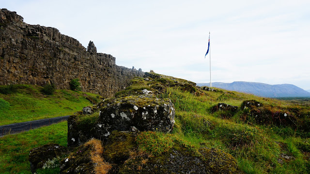 |
| Logberg, the Law Rock at Thingvellir. |
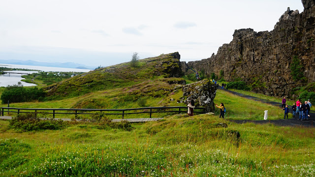 |
| Looking south from the Law Rock: the remnants of a chieftain's camp, Oxarar flowing into Thingvallavatn, and the path to the Visitor Center. |
We then walked further, intent on reaching
Öxarárfoss, the waterfall taking Oxarar from the top of the cliff to its bottom. On the way lies
Drekkingarhylur (someone should translate this page into English from Icelandic!), the place where executions were conducted on the authority of the Allthyngi. Quite literally, Icelanders drowned tens of
suspected witches in the pool at the bottom of this Oxarar's turn towards its final destination: Thingvallavatn.
 |
| List of witches drowned at Drekkingarhylur |
 |
| Drekkingarhylur: the execution place. |
Further up the river, the waterfall, while not the most impressive one we saw today, did not disappoint.
 |
| Öxarárfoss: the front view (carefully hiding the 50 or so people at the observation deck from the view) |
 |
| Öxarárfoss: the panorama, looking downstream. Oxarar flowing towards Drekkingarhylur... |
After the waterfall, we turned back, but used the trails on the other side of the river to walk past the Thingvallir church, and get from panoramic views of the cliffs.
 |
| Thingvellir church using the Retro filter on my Sony Alpha 6000 camera. |
 |
| Öxarárfoss: view from far away. |
 |
| Thingvellir. |
Kerid crater. Kerid crater is located just by the side of a well traveled road (the direct route from Reykjavik to Geysir/Strokkur area), but the route from Thingvellir to it is actually quite empty - were were pretty much on our own until we turned onto Route 35. I was hoping that the empty road - we drove the entire length of the eastern side of Thingvallavatn and then some meant there would be fewer people at the crater, but no such luck. The crater though, is well worth it, and I will let the pictures do the rest of the talking.
 |
| Kerid Crater from the top. |
 |
| Kerid Crater magnified. |
 |
| Kerid Crater with a bit of surrounding landscape. |
 |
| Kerid Crater and yours truly: the obligatory "Oh, yeah, I was there" picture. |
Skalholt. We proceeded to
Skalholt, the second biggest site Iceland has for history - the former seat of the Bishop of Iceland. Unlike the other places along the Golden Circle, this one was rather empty - there were probably three or four other groups of people there when we came. There is a new-ish cathedral on the spot where the abbey used to be.
 |
| Skalholt Cathedral. |
There was an archaeological dig on the hill, which discovered the general layout of the abbey, and found some interesting looking passages under the standing cathedral - passages we were not allowed to explore, unfortunately, although I stepped inside (to set up the proper exposure for a couple of shots) to take pictures.
 |
| A mysterious passage leading under the Skalholt Cathedral. |
 |
From the department of "only in Iceland" - this is the location of the whey storage at the old Skalholt Abbey.
|
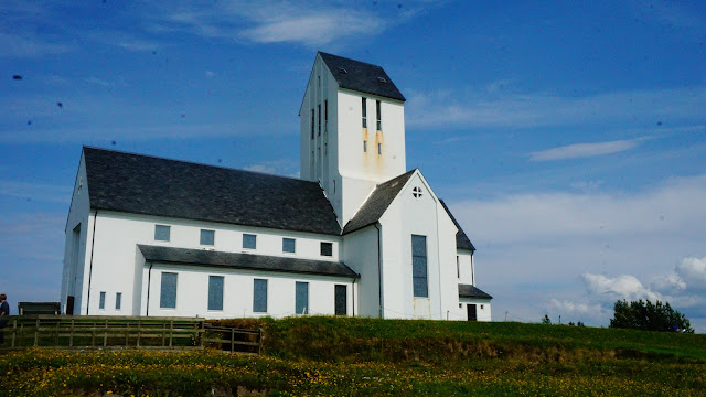 |
One more view of the Skalholt cathedral. |
Geysir and Strokkur. After a quick stop at a local hostel/bistro to get some water, we proceeded to the main attraction of the day the Geysir geothermal area, featuring the
dormant Geysir, and the
very much alive Strokkur. We noticed Strokkur at the location where routes 37 and 35 - about 4.5 kilometers away, but with a clear view of the entire geothermal area. As we were making the turn, Strukkur went up to probably its top height, and was active for close to 5-6 seconds, with a few more seconds of steam in its wake.
We hung out around Strokkur enough to witness about seven or eight eruptions - a few duds at the beginning, but some serious contenders later, including one that got me quite wet and had me (in panic - it was spreading way beyond my frame) flip the camera from horizontal to vertical in the middle of a video shot. Some stills from the various eruptions are below.
 |
| Strokkur: a small eruption. |
 |
| Strokkur: a pretty strong one, but it ended quickly. |
 |
| Strokkur: a big eruption is dying down (I missed its beginning, so only got the waning shots). |
We also visited Geysir, which, of course did not want to erupt.
 |
| Geysir. |
 |
| And more Geysir. |
We then walked around a few smaller geysers. None were doing anything particularly impressive (although a few small geysers on the way from the road to Strokkur bubble constantly), but the make for good pictures. One geyser in particular is situated in a way that allows the camera to look inside it.
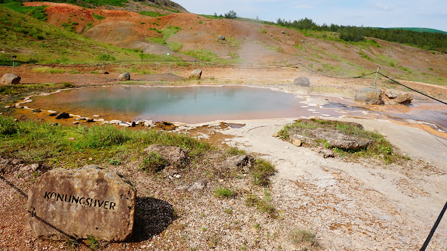 |
| You can read it as well as I: this is Konungshver. |
 |
| Looking inside Blesi. |
 |
| The smaller pool of Blesi. |
 |
| Some smaller hot springs. |
 |
| Strokkur from further away. Waiting for it to go off. |
Gullfoss. At this point, we've been on the road for some seven hours, with some snack breaks, but not much more. After some coffee and cold drinks at the overpriced Geysir cantina, we trekked the 5.6 miles to
Gullfoss. Google maps sent us to the bottom parking lot - we never made it up to get the view of the waterfall. Not a problem though, as the front views were stunning.
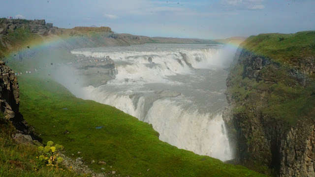 |
| Gullfoss as you approach it. And no, I did not add a rainbow. It was there. |
In terms of sheer power and might, the only other waterfall I can compare it to is Niagara falls. The pictures do not do adequate justice to just how big and powerful this waterfall is.
 |
| Here is the upper fall. |
 |
| And here is the lower fall. |
Yep. The rainbow was there - hanging in the droplets of water that spread from the lower fall all the way towards the observation point, where they made my lens wet - which you can see on some later pictures taken (notice the small circles).
We walked along the path leading to the upper falls. Took some pictures along the way.
 |
| Gullfoss: full view with a rainbow. |
 |
| Side view of the lower falls. |
 |
| Upper falls heading straight at ya. |
 |
| And yep, I was there. |
Hrunalaung. At this point, it's around 4:30pm, kids are tired and ready to head back, so we tell them, next place we go is a hot spring with a chance of taking a soak. This is where our luck runs out. First, maps decides that one thing we have not done yet today is drive a gravel road, and it sends us there. And not a good gravel road. More like a gravel road I am used to back in Russia - bumpy and uneven. We trek on it for mayber 5-6 kilometers before it emerges back into asphalt. Then, to get to Hrunalaung itself, there is another gravel road. This time, I find alternate route - a few mins longer, and still with a gravel road piece, but better road, and - more importantly - shorter one.
So,
Hrunalaung is found on all sorts of "top 10 natural hot springs in Iceland" lists, lies on our way back home (a bit off, but not by much), and we figure, what the heck, it looks promising. We arrive at the place, leave kids in the car (good for them!), and head to the pool itself.
 |
| Hrunalaung, or what's left of it. |
 |
| It looks like there should have been water flowing through there, no? |
The pool is ankle deep. The water is cold, and it just seemed that the whole thing has just dried up.
So, not only we took the really upsetting gravel roads, but we did it for nothing.
Going home. At this point we decide to cut our losses and head home. On the way, I find a Bonus store in Selfoss we can make to before it closes. Kids buy food. We head home.
Driving. Google maps and the odometer agree on 282 kilometers of total distance driven.
Steps. Google fit claims 15,112 steps. We did walk quite a bit - about half of it in Thingvellir, but I am still surprised.
Day 3 plan. Reykjavik. National Museum, old town, and anything else we see along the way.


No comments:
Post a Comment